|
Hurricane Sandy Expected to Skirt Florida Coastline 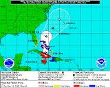 October 25, 2012 | WMFE - Hurricane Sandy is moving over eastern Cuba this morning as a category 2 hurricane. The storm is expected to move north-northeast over the next few days bringing strong onshore winds along the central Florida coastline with steady winds of 25 to 35 mph and gusts up to 50 mph. A tropical storm warning is in effect for the Atlantic Coast from the Upper Keys to Flagler Beach including Brevard and Volusia Counties. The Florida Division of Emergency Management says rip currents, windy conditions and large ocean swells will be Sandy's biggest threats for the Central Florida coastline. Emergency officials say the strong onshore winds will mean very dangerous boating and surf conditions with beach erosion and some coastal flooding possible. Interior counties including Orange, Osceola and Seminole can expect winds gusting up to 35 mph with some showers. The 18th named storm of the Atlantic hurricane season made landfall this morning just west of Santiago de Cuba in southern Cuba with winds of about 105 miles per hour. The storm is expected to maintain hurricane strength as it moves through the Bahamas tonight and tomorrow Wednesday, Sandy roared across Jamaica killing one person. Another person died as a result of rising waters in Haiti. |
|
|