|
Isaac's Path Shifts Slightly in the Gulf, Still Expected to Affect Florida 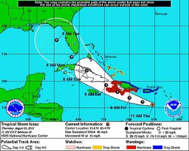 August 23, 2012 | WMFE - Tropical Storm Isaac's projected five-day path has continued to move slightly west of Florida's coastline once it reaches the Gulf of Mexico. However, Florida remains in the cone of uncertainty, and meteorologists say the state will likely feel some effects from Isaac. As of Thursday’s 11:00am update from the National Weather Service, Isaac is just south of Puerto Rico, still moving west at about 15 miles per hour. The storm is packing winds of 40 miles per hour, affecting a 140-mile radius around the system's eye. A turn toward the northwest is expected this afternoon, putting Isaac on a path to skirt just under the Dominican Republic, then cross over Haiti and the eastern half of Cuba before heading into the Florida Straits. A hurricane warning is in effect for the south coast of the Dominican Republic. Puerto Rico, the US Virgin Islands and surrounding areas are under a tropical storm warning. Isaac is expected to become a category 1 hurricane Monday morning as it reaches the Florida Straits and moves into the Gulf of Mexico, skirting up the west coast of Florida to be parallel with Tampa by Tuesday morning. How close the eye of the storm will be to Tampa is unclear, but the city is expected to feel some impact from the storm as the Republican National Convention gets underway Monday. The convention is expected to bring an addition 50,000 to 70,000 people to the Tampa Bay area. You can see the latest updates at the National Hurricane Center here. |
|
|